A Historical Report
The Story of Turkey Creek Road
6170 Turkey Creek Road, Hurricane, WV 25526
Putnam County, West Virginia · March 2026
The Land Before
An Ancient River’s Legacy
The land beneath 6170 Turkey Creek Road holds a geological story that stretches back hundreds of millions of years — and one that involves a river older than the Appalachian Mountains themselves.
This property sits within the Appalachian Plateau Province, a vast, westward-tilting tableland of nearly horizontal sedimentary rock layers deposited during the Paleozoic Era (540–250 million years ago). Specifically, the bedrock belongs to the Kanawha Formation of the Pennsylvanian-age Pottsville Group — a thick sequence of 1,150 to 1,200 feet of sandstone (roughly 50%), shale, siltstone, and coal beds, laid down when this region was a swampy coastal plain near the equator.
The strong Pottsville sandstone creates the razorback ridges that define the surrounding terrain, while softer shales form the valleys where creeks like Turkey Creek have carved their channels over millennia. The region’s mineral wealth extends beyond coal — the Elk-Poca gas field, spanning Jackson, Kanawha, and Putnam counties, has produced over one trillion cubic feet of natural gas from more than 1,000 wells since 1933.
The Teays River: A Ghost Beneath the Valley
Perhaps the most remarkable geological feature of this area is invisible — the Teays River, believed to be the second-oldest river on Earth. Before the Pleistocene Ice Ages (more than 2.5 million years ago), the Teays was a massive waterway that originated in present-day North Carolina, carved what is now the New River Gorge as the Appalachian chain rose around it, and flowed northward through Ohio, Indiana, and Illinois to the Gulf of Mexico.
The modern city of Hurricane sits directly in the ancient Teays Valley, which is approximately one mile wide at this point. Interstate 64 traces the Teays’ historic path from Charleston to Huntington.
During the Ice Ages, continental glaciers created Lake Tight — an ice-dammed lake covering 10,000 square miles that held 268 cubic miles of water — more than twice the volume of Lake Erie — with pockets reaching 300 feet deep.
As the glacier retreated, Lake Tight filled with sediments — 180 feet of gravel and clay accumulated in the Scott Depot area alone. The ghost of the Teays still lingers: when Hurricane’s post office was constructed in 1995, builders hit a deposit of groundwater trapped in the ancient river’s gravels.
Approximately 800,000 years ago, the Ohio River system formed from the redirected glacial meltwater, and the Teays Valley between present-day Nitro and Huntington was abandoned. Turkey Creek and Hurricane Creek now drain portions of what was once this mighty river’s domain.
Turkey Creek
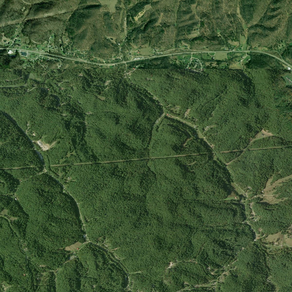
Turkey Creek is a stream in the south-central portion of Putnam County, flowing through a narrow valley carved into the Appalachian Plateau’s sandstone and shale. The terrain is characterized by steep, forested hillsides rising from the creek bottom, with elevations ranging from roughly 600 to 1,200 feet — classic dissected plateau topography.
The original ecosystem was Appalachian mixed mesophytic forest — one of the most biodiverse temperate forest types on Earth, with canopies containing up to 50 hardwood species: American beech, yellow poplar, basswood, sugar maple, American chestnut (before the blight), sweet buckeye, and dozens more. These forests have persisted for over 100 million years in the unglaciated Central Appalachian coves — theorized to be the ancestral source of most temperate-zone forest species in eastern North America.

USDA NAIP aerial photography showing the Turkey Creek valley and surrounding ridges
First Peoples
People have lived in the Kanawha Valley for 12,500 years, making this one of the longest continuously inhabited regions in North America.
12,500+ years ago
Paleo-Indians
The earliest inhabitants were Paleo-Indian hunters who pursued megafauna — mastodons, giant ground sloths, and ancient bison — using distinctive Clovis fluted points. Four such points have been discovered along the Elk River in Charleston, with additional finds at Winfield (the Putnam County seat, just miles from Turkey Creek). These people lived in small, mobile bands, following game across a landscape transitioning from tundra-like conditions to temperate forest.
10,000–3,000 years ago
Archaic Period
As the climate warmed, Archaic peoples adapted by hunting deer with atlatls (spear-throwers) and gathering the rich plant resources of the emerging deciduous forest. They manufactured tools from Kanawha Black Flint, a locally sourced stone that became a signature material of the region’s toolmaking tradition.
3,000–900 years ago
Woodland Period & the Adena Mound Builders
The Adena people built at least 50 earthwork mounds and 10 enclosures between Charleston and Dunbar — the Kanawha Valley once had the highest concentration of burial mounds in North America. The Criel Mound in South Charleston, excavated by the Smithsonian in 1883, revealed an Adena leader buried with a copper headdress, shell beads, and a flint knife — evidence of a vast trade network connecting the Kanawha Valley to the Gulf Coast, Atlantic Coast, and Great Lakes.
900–300 years ago
Fort Ancient Culture
The Fort Ancient people established permanent circular villages on river terraces, practicing agriculture based on corn, beans, and squash — the “Three Sisters” of Eastern Woodlands farming. The Buffalo Village site in Putnam County — one of the largest excavated Native American villages in the state — is just a few miles from Turkey Creek.
~300 years ago
The Historic Period
The Iroquois Confederacy drove the Fort Ancient peoples from the Kanawha Valley. By the time European settlers arrived, all permanent villages were gone, and the area served as a shared hunting ground used by the Iroquois, Shawnee, Delaware, Mingo, and Cherokee.
This era ended on October 10, 1774, when Chief Cornstalk led 1,200 warriors against colonial forces at the Battle of Point Pleasant — roughly 40 miles downstream from Turkey Creek. The subsequent Treaty of Camp Charlotte opened the Kanawha Valley to Euro-American settlement.
Settlement & Homesteading
The First Settlers
The ink on the Treaty of Camp Charlotte was barely dry when settlers began pushing into the Kanawha Valley. James Conner, arriving from eastern Virginia in 1777, conducted extensive exploration of the Hurricane area and obtained substantial land grants from Virginia’s governor, potentially acquiring 4,000–5,000 acres in the region.
The James River & Kanawha Turnpike
Around 1815, a settlement formed near present-day eastern Hurricane called Hurricane Creek Bridge, serving as a stop on the James River & Kanawha Turnpike — the main overland route connecting the Shenandoah Valley to the Ohio River, originally proposed by George Washington and completed in 1832. This turnpike, following modern US Route 60, was the commercial lifeline of the region.
In 1774, surveyors working under commission from George Washington discovered the confluence of a large creek where they “observed bending trees all facing the same way, likely the effects of a storm, and said it was ‘the place of a hurricane.’”
Turkey Creek’s Early Families
The Turkey Creek community developed as part of the broader agricultural settlement of southern Putnam County. On July 2, 1870, A.H. Thornton purchased 50 acres on Turkey Creek from Richard Byrnside — one of many small-acreage transactions that characterized the area’s pattern of family farming. Thomas Jefferson Thornton operated a store on Turkey Creek, serving as a commercial hub for the scattered farming families along the hollow.
County Formation
Putnam County was established on March 11, 1848, carved from portions of Kanawha, Mason, and Cabell counties. Named for General Israel Putnam, who commanded Continental forces at the Battle of Bunker Hill, the 1850 census recorded 5,336 residents — including 632 enslaved people, reflecting the county’s position in the border region.
Unlike western territories surveyed under the Township-Range-Section system, West Virginia is a “state land state” — property was described using metes and bounds (natural landmarks, compass bearings, and measured distances). Property histories along Turkey Creek must be traced through the Putnam County Courthouse and the West Virginia State Archives.
Agricultural & Economic Development
A Farming County
Putnam County was “entirely a farming county until the late 1800s.” The rolling hills and creek bottoms of the Turkey Creek area supported small-scale agriculture — corn, hay, tobacco, and livestock. Putnam is one of six plateau counties in West Virginia where tobacco became a specialty crop, with millions of pounds of burley tobacco stored and auctioned at warehouses in Milton and Hurricane until the early 2000s.
The Turkey Creek hollow, like many in the county, supported a pattern of subsistence and small-market farming — families grew what they needed, raised hogs and cattle on the hillsides, and sold modest surpluses at stores like Thomas Jefferson Thornton’s.
The Salt Industry
The broader regional economy was shaped by the Kanawha salt industry. At a salt spring along the Kanawha River near Malden, deer and buffalo had long gathered at the Great Buffalo Lick. In 1797, Elisha Brooks established the first commercial salt furnace, and by 1815, 52 furnaces were operating.
In 1817, David Ruffner switched from wood to coal fuel — permanently linking the salt and coal industries. Production peaked in 1846 at an astonishing 3,224,786 bushels, making the Kanawha Valley one of the largest salt manufacturing centers in the United States. The 1861 flood and Civil War devastation nearly destroyed the industry; only the Dickinson furnace at Malden survived. (J.Q. Dickinson Salt-Works continues today as an artisan operation.)
Coal Mining
Though coal was discovered on the Pocatalico River as early as 1798, it remained largely unmined commercially until the late 19th century. By 1907, five mining companies employed roughly 1,000 workers and produced over 400,000 tons annually.
The Railroad Transforms Everything
The arrival of the Chesapeake & Ohio Railway in the 1870s fundamentally changed the region. Hurricane Creek Bridge became Hurricane Station, connected to national markets for the first time. The railroad ran through the Teays Valley, roughly following the ancient Teays River’s path — setting the stage for the corridor of development that would eventually become Interstate 64.

USGS 1:24,000 Hurricane Quadrangle, 1958 — showing the area before Interstate 64 construction
Modern Development
Civil War: The Battle of Scary Creek
The Civil War divided Putnam County — roughly 400 soldiers served on each side. The most notable engagement was the Battle of Scary Creek on July 17, 1861 — the first Confederate victory in the Kanawha Valley. About 1,300 Union troops under Brigadier General Jacob D. Cox clashed with 900 Confederates under Brigadier General Henry A. Wise. Confederate Captain Albert Jenkins (later a general) led his side to victory after Colonel George S. Patton — grandfather of the WWII general — was wounded.
Incorporation and Growth
Hurricane was formally incorporated in 1888. The 20th century brought transformative change:
- 1957The Winfield Bridge finally connected the northern and southern halves of Putnam County, which the Kanawha River had divided for over a century.
- 1960sInterstate 64 was constructed through the Teays Valley, placing Hurricane directly on the corridor between Charleston and Huntington.
- 1970sHurricane achieved city status when its population surpassed 3,000 residents.
- 1990sToyota established a major manufacturing facility in the county, becoming one of the largest employers.
Population Explosion
The numbers tell the story of I-64’s impact:
| Year | Putnam County | Hurricane |
|---|---|---|
| 1850 | 5,336 | — |
| 1960 | — | ~2,000 |
| 1970 | — | ~3,000 |
| 1990 | — | 4,461 |
| 2000 | 51,589 | 5,222 |
| 2010 | 55,486 | 6,284 |
| 2020 | 57,440 | 6,977 |
Hurricane’s 2020 population of 6,977 represents more than double the 1970 figure. Between 2010 and 2020, Hurricane was the second-fastest-growing community in West Virginia. Putnam County has been one of the fastest-growing counties in the state — remarkable in a state where most counties have been losing population for decades.
Flooding
The June 2016 “thousand-year” rainfall event devastated communities in Kanawha, Nicholas, and Greenbrier counties, killing 23 people. Turkey Creek Road, situated in a narrow valley, is characteristic of the hollows where flash flooding can be a concern during extreme weather.
The Area Today
Turkey Creek: A Place Apart
While Hurricane has grown into a bustling suburban center, the Turkey Creek valley retains much of its rural, Appalachian character. Turkey Creek Road winds south from the Hurricane area into the hollows of southern Putnam County — a landscape of narrow creek bottoms flanked by steep, forested ridges.
This is a place where the deep quiet of the hills contrasts with the commercial bustle of the Hurricane/I-64 corridor just a few miles away — rural solitude within easy reach of modern amenities.
The Banjo Man from Turkey Creek
Turkey Creek’s most famous son is Elmer Bird (1920–1997), one of America’s premier old-time banjo musicians. Born into a family of 11 children, Bird taught himself the drop-thumb clawhammer style by watching his father play evenings after farm work.
After World War II service in North Africa and Sicily, Bird married Beulah Edwards in 1945 and started farming on Turkey Creek. A pivotal 1975 meeting with Grammy winner John Hartford led to Hartford producing several of his albums.
The Society for the Preservation of Bluegrass Music in America named Elmer Bird the nation’s best old-time banjo player in 1984, 1985, 1986, and 1990. He received West Virginia’s highest folklife honor — the Vandalia Award — in 1996.
His album The Banjo Man from Turkey Creek remains a beloved document of Appalachian musical tradition — and a testament to the creative spirit that has always flourished in these hills.
Nearby Points of Interest
- Hurricane City Park — picnic areas, playgrounds, athletic fields, sprayground, and fishing pier
- Valley Park & Waves of Fun — water park, walking trails, ponds, and dog park
- Meeks Mountain Trails — 20+ miles of hiking trails in the hills above Hurricane
- Charleston — state capital, ~30 miles east via I-64
- Huntington — Marshall University city, ~30 miles west via I-64
Sources & Further Reading
Primary Sources
- e-WV: The West Virginia Encyclopedia — Hurricane, Putnam County, Teays River, Elmer Bird, Battle of Scary Creek, Geology, Mound Builders, Tobacco
- CWVA: Kanawha Valley Prehistory — Archaeological record and indigenous cultures
- Hurricane Breeze — Local perspective on Teays River geological history
- WVGS — Kanawha salt industry history, Kanawha Formation geological data
- City of Hurricane — Official city history
- WV Public Broadcasting — Native American history overview
- NOAA Climate.gov — 2016 flooding event analysis
- LOC — Mixed mesophytic forest ecology
- FamilySearch — West Virginia land and property systems
Imagery & Map Sources
- Satellite imagery: ESRI World Imagery via ArcGIS REST Services
- Aerial photography: USGS NAIP Plus (National Agriculture Imagery Program)
- 1892 Huntington topo (1:125k): USGS Historical Topographic Maps
- 1899 Charleston topo (1:125k): USGS Historical Topographic Maps
- 1958 Hurricane topo (1:24k): USGS Historical Topographic Maps
Archives for Further Research
- Putnam County Courthouse — Land records from 1841, deeds, surveys
- WV State Archives — Historical documents, photographs
- USGS TopoView — Browse historical topo maps by location and date
- ESRI Wayback Imagery — Satellite imagery year-by-year since 2014
- WV Property Viewer — Current parcel data, ownership, zoning
- WVU Archives — Putnam County historical collections
- David Rumsey Map Collection — Georeferenced historical maps
Additional USGS Historical Topo Maps
- Garretts Bend, WV — 1:24,000 (1958) — Covers Turkey Creek area directly
- Hurricane, WV — 1:24,000 (1958) — Hurricane and northern approach
- Hamlin, WV — 1:24,000 (1958) — Area west of Turkey Creek
- Charleston, WV — 1:100,000 (1984) — Broad regional context
- Huntington, WV — 1:100,000 (1982) — Western regional context
- Charleston, WV — 1:125,000 (1899) — Earliest detailed survey
- Huntington, WV — 1:125,000 (1892) — Earliest regional survey
Report prepared for Critter Creek Property
6170 Turkey Creek Road, Hurricane, WV 25526
Compiled March 2026