A Historical Report
The Story of Tacketts Branch Road
756 & 758 Tacketts Branch Road, Hurricane, WV 25526
Putnam County, West Virginia · March 2026
The Land Before
Standing on the Floor of an Ancient River
The land beneath 756 and 758 Tacketts Branch Road holds a geological story that stretches back hundreds of millions of years. This property sits within the Appalachian Plateau Province, a vast, westward-tilting tableland of nearly horizontal sedimentary rock layers deposited during the Paleozoic Era (540–250 million years ago).
The bedrock belongs to the Kanawha Formation of the Pennsylvanian-age Pottsville Group — a thick sequence of 1,150 to 1,200 feet of sandstone (roughly 50%), shale, siltstone, and coal beds, laid down when this region was a swampy coastal plain near the equator. The strong Pottsville sandstone creates the ridges that frame the surrounding terrain, while softer shales form the valleys where streams have carved their channels over millennia.
The Teays River: Directly Beneath Your Feet
What makes Tacketts Branch Road extraordinary is its position directly on the Teays Valley floor. The Teays River — believed to be the second-oldest river on Earth — once carved this broad valley as a massive waterway originating in present-day North Carolina, flowing northward through Ohio, Indiana, and Illinois to the Gulf of Mexico. Before the Pleistocene Ice Ages (more than 2.5 million years ago), the Teays was the dominant river system of eastern North America.
The modern city of Hurricane sits directly in the ancient Teays Valley, which is approximately one mile wide at this point. Tacketts Branch Road, closer to the valley center than Turkey Creek to the south, occupies some of the flattest, most fertile terrain in the region — the ancient riverbed itself.
During the Ice Ages, continental glaciers created Lake Tight — an ice-dammed lake covering 10,000 square miles that held 268 cubic miles of water — more than twice the volume of Lake Erie — with pockets reaching 300 feet deep.
As glaciers retreated, Lake Tight filled the Teays Valley with sediments — 180 feet of gravel and clay accumulated in the Scott Depot area alone. These deep sediment deposits created the gently rolling terrain that makes the Tacketts Branch area ideal for development. When Hurricane’s post office was constructed in 1995, builders hit a deposit of groundwater trapped in the ancient river’s gravels — the ghost of the Teays still lingers beneath the surface.
Approximately 800,000 years ago, the Ohio River system formed from redirected glacial meltwater, and the Teays Valley between present-day Nitro and Huntington was abandoned. Hurricane Creek and its tributaries, including Tacketts Branch, now drain portions of what was once this mighty river’s domain.
Hurricane Creek Watershed
Tacketts Branch is a tributary of Hurricane Creek, part of the broader Hurricane Creek watershed that drains southward into the Kanawha River. Unlike the steep, narrow hollows of nearby Turkey Creek, the Tacketts Branch area benefits from the wide, gentle topography of the Teays Valley floor. Elevations here are lower and more consistent, ranging from roughly 600 to 700 feet — a landscape shaped more by ancient river deposition than by the erosive carving that defines the surrounding ridges.
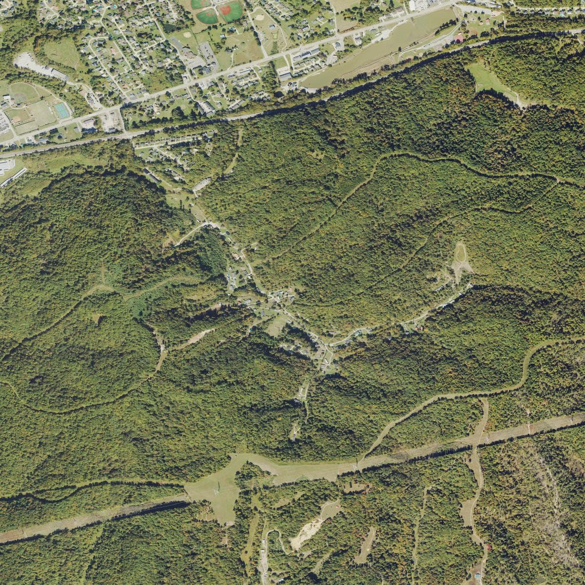
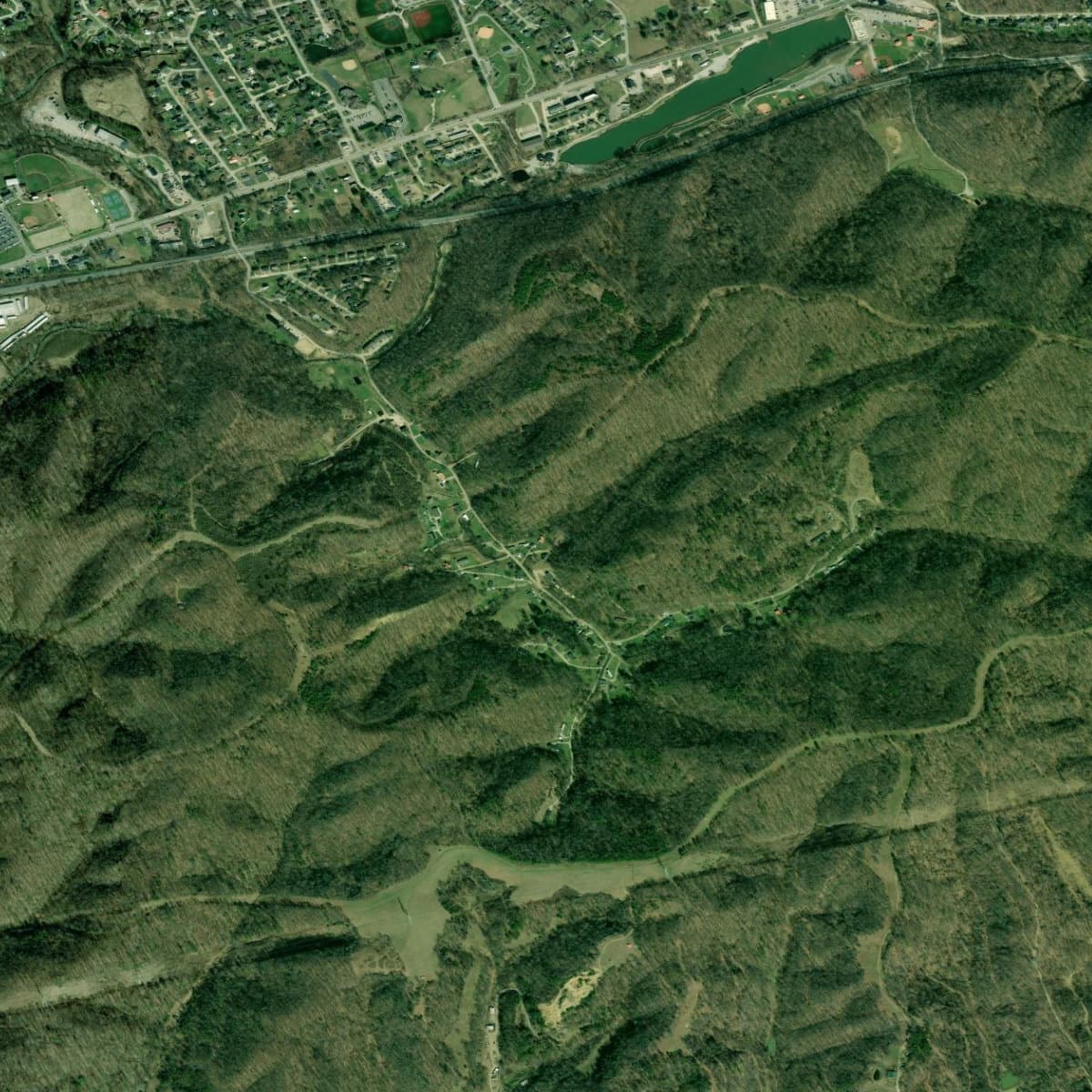
USDA NAIP aerial photography showing the Tacketts Branch area and surrounding development
First Peoples
People have lived in the Kanawha Valley for 12,500 years, making this one of the longest continuously inhabited regions in North America. The broad, fertile Teays Valley floor — where Tacketts Branch Road now sits — would have been prime territory for every culture that called this region home.
12,500+ years ago
Paleo-Indians
The earliest inhabitants were Paleo-Indian hunters who pursued megafauna — mastodons, giant ground sloths, and ancient bison — using distinctive Clovis fluted points. Four such points have been discovered along the Elk River in Charleston, with additional finds at Winfield (the Putnam County seat, just miles from Tacketts Branch). The wide, open valley floor would have provided ideal hunting grounds and seasonal campsites.
10,000–3,000 years ago
Archaic Period
As the climate warmed, Archaic peoples adapted by hunting deer with atlatls (spear-throwers) and gathering the rich plant resources of the emerging deciduous forest. They manufactured tools from Kanawha Black Flint, a locally sourced stone that became a signature material of the region’s toolmaking tradition. The Teays Valley floor, with its reliable water sources and gentle terrain, would have supported semi-permanent base camps.
3,000–900 years ago
Woodland Period & the Adena Mound Builders
The Adena people built at least 50 earthwork mounds and 10 enclosures between Charleston and Dunbar. The Kanawha Valley once had the highest concentration of burial mounds in North America. The Criel Mound in South Charleston, excavated by the Smithsonian in 1883, revealed an Adena leader buried with a copper headdress, shell beads, and a flint knife — evidence of a vast trade network connecting the Kanawha Valley to the Gulf Coast, Atlantic Coast, and Great Lakes.
900–300 years ago
Fort Ancient Culture
The Fort Ancient people established permanent circular villages on river terraces, practicing agriculture based on corn, beans, and squash. The Buffalo Village site in Putnam County — one of the largest excavated Native American villages in the state — is located just a few miles from Tacketts Branch. The proximity of this major archaeological site suggests the Tacketts Branch area was well within the territory of these agricultural communities.
~300 years ago
The Historic Period
The Iroquois Confederacy drove the Fort Ancient peoples from the Kanawha Valley. By the time European settlers arrived, all permanent villages were gone, and the area served as a shared hunting ground used by the Iroquois, Shawnee, Delaware, Mingo, and Cherokee.
This era ended on October 10, 1774, when Chief Cornstalk led 1,200 warriors against colonial forces at the Battle of Point Pleasant — roughly 40 miles downstream. The subsequent Treaty of Camp Charlotte opened the Kanawha Valley to Euro-American settlement.
Settlement & Homesteading
The Tackett Family Legacy
The road’s name tells its own story. The Tackett family was among the earliest and most prominent pioneer families in the Virginia frontier that became West Virginia. Lewis Tackett, a Scots-Irish settler, arrived in the upper Big Sandy River area in the late 1700s, and the family spread across southwestern Virginia and what is now West Virginia over the following decades.
Tacketts were among the families who took up land grants in Putnam County after the Treaty of Camp Charlotte opened the Kanawha Valley to settlement. The branch (creek) that bears their name was likely the site of an early Tackett homestead — a common naming pattern in Appalachian topography where waterways were identified by the families who settled along them.
The James River & Kanawha Turnpike
Around 1815, a settlement formed near present-day eastern Hurricane called Hurricane Creek Bridge, serving as a stop on the James River & Kanawha Turnpike — the main overland route connecting the Shenandoah Valley to the Ohio River, originally proposed by George Washington and completed in 1832. This turnpike, following modern US Route 60, passed closer to the Tacketts Branch area than to the more remote hollows to the south.
In 1774, surveyors working under commission from George Washington discovered the confluence of a large creek where they “observed bending trees all facing the same way, likely the effects of a storm, and said it was ‘the place of a hurricane.’”
County Formation
Putnam County was established on March 11, 1848, carved from portions of Kanawha, Mason, and Cabell counties. Named for General Israel Putnam, who commanded Continental forces at the Battle of Bunker Hill, the 1850 census recorded 5,336 residents — including 632 enslaved people, reflecting the county’s position in the border region.
Unlike western territories surveyed under the Township-Range-Section system, West Virginia is a “state land state” — property was described using metes and bounds (natural landmarks, compass bearings, and measured distances). Property histories along Tacketts Branch must be traced through the Putnam County Courthouse and the West Virginia State Archives.
Agricultural & Economic Development
A Farming County
Putnam County was “entirely a farming county until the late 1800s.” The Teays Valley floor around Tacketts Branch was among the best farmland in the county — flatter, more fertile, and easier to work than the steep hollows to the south. Families grew corn, hay, and tobacco, and raised hogs and cattle on the surrounding hillsides.
Putnam is one of six plateau counties in West Virginia where tobacco became a specialty crop, with millions of pounds of burley tobacco stored and auctioned at warehouses in Milton and Hurricane until the early 2000s. The broader, more accessible farms near Tacketts Branch likely produced more market-oriented crops than the subsistence farms deeper in the hollows.
The Salt Industry
The broader regional economy was shaped by the Kanawha salt industry. At a salt spring along the Kanawha River near Malden, deer and buffalo had long gathered at the Great Buffalo Lick. By 1815, 52 furnaces were operating. Production peaked in 1846 at an astonishing 3,224,786 bushels, making the Kanawha Valley one of the largest salt manufacturing centers in the United States.
The Railroad Transforms Everything
The arrival of the Chesapeake & Ohio Railway in the 1870s fundamentally changed the region — and Tacketts Branch felt this transformation more directly than the remote hollows. The railroad ran through the Teays Valley, roughly following the ancient Teays River’s path, passing within a few miles of the Tacketts Branch area. Hurricane Creek Bridge became Hurricane Station, connected to national markets for the first time.
The C&O Railway set the stage for the corridor of development that would eventually become Interstate 64 — and both followed the same ancient valley floor that Tacketts Branch Road occupies.
Coal Mining
Though coal was discovered on the Pocatalico River as early as 1798, it remained largely unmined commercially until the late 19th century. By 1907, five mining companies employed roughly 1,000 workers and produced over 400,000 tons annually. The coal economy brought workers and investment to the broader region, fueling Hurricane’s growth as a service center.
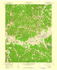
USGS 1:24,000 Hurricane Quadrangle, 1958 — showing the area before Interstate 64 construction
Modern Development
Civil War: The Battle of Scary Creek
The Civil War divided Putnam County — roughly 400 soldiers served on each side. The most notable engagement was the Battle of Scary Creek on July 17, 1861 — the first Confederate victory in the Kanawha Valley. About 1,300 Union troops under Brigadier General Jacob D. Cox clashed with 900 Confederates under Brigadier General Henry A. Wise. Confederate Captain Albert Jenkins led his side to victory after Colonel George S. Patton — grandfather of the WWII general — was wounded.
Interstate 64: The Valley Transforms Again
The construction of Interstate 64 in the 1960s was the defining event for the Tacketts Branch area. The interstate was built directly through the Teays Valley, passing within a mile of the properties at 756 and 758 Tacketts Branch Road. This wasn’t coincidence — highway engineers followed the same flat terrain that the Teays River, the C&O Railway, and the James River & Kanawha Turnpike had all followed before.
I-64 transformed Hurricane from a quiet railroad town into a bedroom community for Charleston and Huntington, both 30 minutes away. The Tacketts Branch area, with its proximity to interstate exits and the gently rolling Teays Valley topography, became prime residential development territory.
Growth Milestones
The transformation was rapid:
- 1957The Winfield Bridge connected the northern and southern halves of Putnam County, which the Kanawha River had divided for over a century.
- 1960sInterstate 64 was constructed through the Teays Valley, placing Hurricane directly on the corridor between Charleston and Huntington.
- 1970sHurricane achieved city status when its population surpassed 3,000 residents.
- 1990sToyota established a major manufacturing facility in the county, becoming one of the largest employers.
Population Explosion
| Year | Putnam County | Hurricane |
|---|---|---|
| 1850 | 5,336 | — |
| 1960 | — | ~2,000 |
| 2000 | 51,589 | 5,222 |
| 2010 | 55,486 | 6,284 |
| 2020 | 57,440 | 6,977 |
Between 2010 and 2020, Hurricane was the second-fastest-growing community in West Virginia. Putnam County has been one of the fastest-growing counties in the state — remarkable in a state where most counties have been losing population for decades.
The Area Today
Suburban Living on Ancient Ground
The Tacketts Branch area occupies a sweet spot in the Hurricane landscape — residential neighborhoods with a suburban character, set on the gentle terrain of the Teays Valley floor, with quick access to modern amenities. Unlike the rural hollows of Turkey Creek to the south, this area is firmly within Hurricane’s suburban fabric.
The properties at 756 and 758 Tacketts Branch Road sit in a quiet residential setting just minutes from Hurricane High School, grocery stores, and I-64 exits. It’s a place where the deep geological history of the Teays Valley meets the everyday convenience of one of West Virginia’s fastest-growing communities.
Schools & Amenities
The Tacketts Branch properties are particularly well-situated for families. Hurricane High School is less than a mile away, and Hurricane Middle School is within two miles. The area is served by the Putnam County school system, consistently rated among the top districts in West Virginia.
Nearby Points of Interest
- Hurricane High School — less than 1 mile
- Hurricane City Park — picnic areas, playgrounds, athletic fields, sprayground, and fishing pier
- Valley Park & Waves of Fun — water park, walking trails, ponds, and dog park
- Walmart & Kroger — grocery shopping within 5 minutes
- I-64 Exit 34 — Charleston (~30 min east) and Huntington (~30 min west)
Sources & Further Reading
Primary Sources
- e-WV: The West Virginia Encyclopedia — Hurricane, Putnam County, Teays River, Battle of Scary Creek, Geology, Mound Builders, Tobacco
- CWVA: Kanawha Valley Prehistory — Archaeological record and indigenous cultures
- Hurricane Breeze — Local perspective on Teays River geological history
- WVGS — Kanawha salt industry history, Kanawha Formation geological data
- City of Hurricane — Official city history
- WV Public Broadcasting — Native American history overview
- Tackett family histories — Various genealogical databases including FamilySearch
Imagery & Map Sources
- Satellite imagery: ESRI World Imagery via ArcGIS REST Services
- Aerial photography: USGS NAIP Plus (National Agriculture Imagery Program)
- 1958 Hurricane topo (1:24k): USGS Historical Topographic Maps
Archives for Further Research
- Putnam County Courthouse — Land records from 1841, deeds, surveys
- WV State Archives — Historical documents, photographs
- USGS TopoView — Browse historical topo maps by location and date
- WV Property Viewer — Current parcel data, ownership, zoning
- WVU Archives — Putnam County historical collections
Report prepared for Critter Creek Property
756 & 758 Tacketts Branch Road, Hurricane, WV 25526
Compiled March 2026