A Historical Report
The Story of Buff Creek
472 Buff Creek Road, Hurricane, WV 25526
Putnam County, West Virginia · March 2026
The Land Before
A Creek Named for the Buffalo
The name “Buff Creek” is itself a window into history. Throughout the Appalachian frontier, “buff” and “buffalo” place names mark the trails and watering holes once used by the Eastern bison ( Bison bison) — herds that roamed these valleys by the thousands before European settlement. The creek was named for the buffalo that drank from its waters, wore paths along its banks, and attracted the hunters — both indigenous and colonial — who followed them.
The land beneath 472 Buff Creek Road sits within the Appalachian Plateau Province, a vast, westward-tilting tableland of nearly horizontal sedimentary rock deposited during the Paleozoic Era (540–250 million years ago). The bedrock belongs to the Kanawha Formation of the Pennsylvanian-age Pottsville Group — a thick sequence of sandstone, shale, siltstone, and coal beds laid down when this region was a swampy coastal plain near the equator.
The Teays River & Buff Creek Watershed
Like all waterways in this area, Buff Creek exists because of the Teays River — believed to be the second-oldest river on Earth. Before the Pleistocene Ice Ages, the Teays was a massive waterway that carved the broad valley where Hurricane now sits. When continental glaciers blocked and destroyed the Teays roughly 800,000 years ago, the smaller streams that remained — including Hurricane Creek and its tributaries like Buff Creek — inherited the drainage of this ancient landscape.
During the Ice Ages, continental glaciers created Lake Tight — an ice-dammed lake covering 10,000 square miles that held 268 cubic miles of water — more than twice the volume of Lake Erie. The sediments it left behind shaped the valleys and hollows of Putnam County.
Buff Creek flows through a narrow hollow cut into the Appalachian Plateau’s sandstone and shale — classic dissected plateau topography with steep, forested hillsides rising from the creek bottom. Elevations range from roughly 600 feet at the creek to over 1,000 feet on the surrounding ridges. The original ecosystem was Appalachian mixed mesophytic forest — one of the most biodiverse temperate forest types on Earth, with canopies containing up to 50 hardwood species.

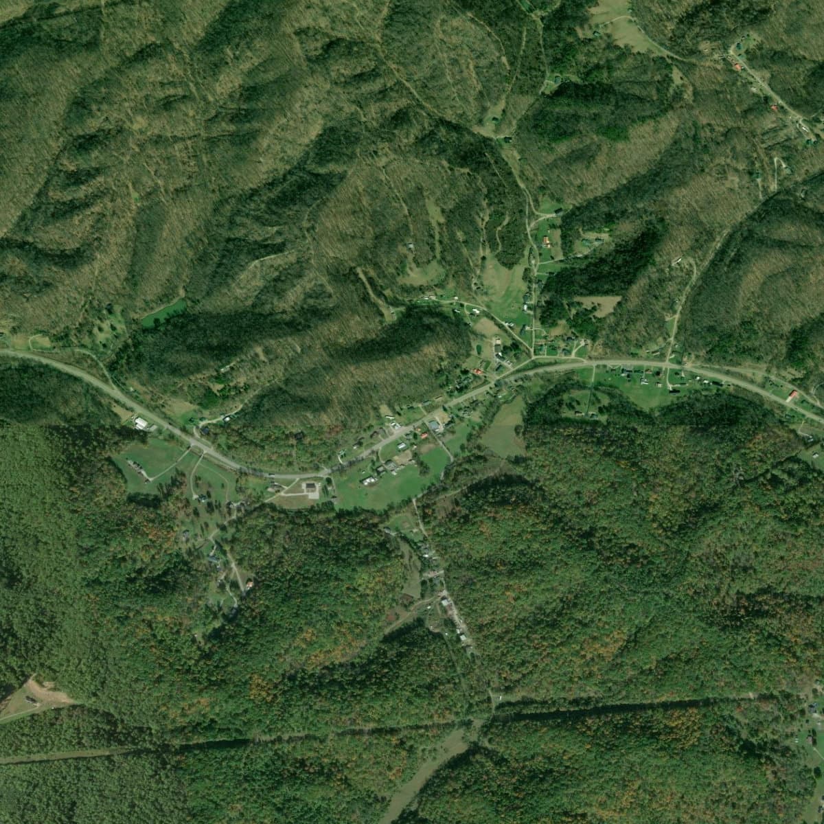
USDA NAIP aerial photography showing the Buff Creek hollow and surrounding ridges
First Peoples
People have lived in the Kanawha Valley for 12,500 years. The creek hollows of southern Putnam County — rich with game, clean water, and sheltering terrain — would have been valued hunting and foraging territory throughout this immense span of human habitation.
12,500+ years ago
Paleo-Indians
The earliest inhabitants were Paleo-Indian hunters who pursued megafauna — mastodons, giant ground sloths, and ancient bison — using distinctive Clovis fluted points. Finds at Winfield (the Putnam County seat) and along the Elk River in Charleston document their presence in this area. Narrow creek valleys like Buff Creek would have served as natural game funnels, concentrating animals at water crossings where hunters could ambush them.
10,000–3,000 years ago
Archaic Period
As the climate warmed, Archaic peoples hunted deer with atlatls and gathered the rich plant resources of the emerging deciduous forest. They manufactured tools from Kanawha Black Flint, a locally sourced stone. Creek hollows provided not just water and game, but also shelter from winter winds and reliable nut-bearing trees — walnuts, hickories, and chestnuts — on the surrounding slopes.
3,000–900 years ago
Woodland Period & the Adena Mound Builders
The Adena people built at least 50 earthwork mounds and 10 enclosures between Charleston and Dunbar — the Kanawha Valley once had the highest concentration of burial mounds in North America. The Criel Mound in South Charleston revealed an Adena leader buried with a copper headdress, shell beads, and a flint knife — evidence of a vast trade network stretching from the Gulf Coast to the Great Lakes.
900–300 years ago
Fort Ancient Culture
The Fort Ancient people established permanent circular villages on river terraces, practicing “Three Sisters” agriculture (corn, beans, squash). The Buffalo Village site in Putnam County — named, like Buff Creek, for the bison that defined this landscape — is one of the largest excavated Native American villages in the state and lies just a few miles from the Buff Creek hollow.
~300 years ago
The Historic Period
The Iroquois Confederacy drove the Fort Ancient peoples from the valley. By the time Europeans arrived, the area served as a shared hunting ground for the Iroquois, Shawnee, Delaware, Mingo, and Cherokee. The buffalo trails that gave Buff Creek its name were used by indigenous hunting parties long before colonial scouts followed them.
On October 10, 1774, the Battle of Point Pleasant — roughly 40 miles downstream — opened the Kanawha Valley to Euro-American settlement via the Treaty of Camp Charlotte.
Settlement & Homesteading
Following the Buffalo Traces
The first Euro-American settlers in the Hurricane area followed paths already worn by centuries of buffalo traffic and indigenous use. James Conner, arriving from eastern Virginia in 1777, conducted extensive exploration and obtained substantial land grants — potentially 4,000–5,000 acres in the region.
Creek hollows like Buff Creek were settled by families who claimed narrow strips of bottomland along the water, with grazing rights extending up the hillsides. The “Buff Creek” name — recorded in early land documents — suggests that buffalo were still present or recently gone when the first deeds were filed. Eastern bison were essentially extirpated from West Virginia by the early 1800s, but their memory persisted in dozens of place names across the state: Buffalo, Buff Creek, Buffalo Village, Great Buffalo Lick.
Throughout the Appalachian frontier, “buff” and “buffalo” place names mark the trails and watering holes of the Eastern bison — herds that roamed these valleys by the thousands before European settlement erased them from the landscape.
County Formation
Putnam County was established on March 11, 1848, from portions of Kanawha, Mason, and Cabell counties. The 1850 census recorded 5,336 residents. Families along Buff Creek would have done their legal business at the courthouse in Winfield, the county seat on the Kanawha River.
West Virginia is a “state land state” where property was described using metes and bounds — natural landmarks, compass bearings, and measured distances. Property histories along Buff Creek must be traced through the Putnam County Courthouse and the West Virginia State Archives.
Agricultural & Economic Development
Hollow Farming
Putnam County was “entirely a farming county until the late 1800s.” The Buff Creek hollow, like hundreds of similar creek valleys across the Appalachian Plateau, supported a pattern of subsistence and small-market farming. Families grew corn, hay, and tobacco on the narrow bottomlands, raised hogs that foraged in the surrounding forests, and kept cattle on the hillsides.
Putnam is one of six plateau counties in West Virginia where tobacco became a specialty crop. Millions of pounds of burley tobacco were stored and auctioned at warehouses in Milton and Hurricane until the early 2000s. For Buff Creek families, the trip to market meant a wagon ride out of the hollow to the turnpike or, later, the railroad station at Hurricane.
The Salt & Coal Economy
The broader regional economy was shaped by the Kanawha salt industry — production peaked in 1846 at 3,224,786 bushels — and later by coal mining. By 1907, five mining companies employed roughly 1,000 workers in Putnam County. While Buff Creek itself was not a major mining area, the coal economy brought workers and investment to the broader region, creating markets for the agricultural products that hollow farmers produced.
The Railroad Era
The arrival of the Chesapeake & Ohio Railway in the 1870s connected Hurricane to national markets. For families in creek hollows like Buff Creek, the railroad meant access to manufactured goods and a way to ship surplus crops beyond the local area. Hurricane Creek Bridge became Hurricane Station, and the small town began its long transformation from isolated rural settlement to connected community.

USGS 1:24,000 Hurricane Quadrangle, 1958 — showing the area before Interstate 64 construction
Modern Development
Civil War in the Valley
The Civil War divided Putnam County — roughly 400 soldiers served on each side. The Battle of Scary Creek on July 17, 1861, was the first Confederate victory in the Kanawha Valley. For families in the creek hollows, the war brought uncertainty, divided loyalties, and economic hardship as the regional salt and agricultural economies were disrupted.
Interstate 64 & Regional Growth
The construction of Interstate 64 in the 1960s transformed the entire region. While I-64 runs through the Teays Valley north of the Buff Creek hollow, its impact was felt everywhere — Hurricane became a bedroom community for Charleston and Huntington, and the surrounding countryside gradually transitioned from agricultural to residential use.
Growth Milestones
- 1957The Winfield Bridge connected both halves of Putnam County across the Kanawha River.
- 1960sInterstate 64 placed Hurricane on the Charleston–Huntington corridor.
- 1990sToyota established a major manufacturing facility, becoming one of the county’s largest employers.
- 2020Putnam County reached 57,440 residents, making it one of the fastest-growing counties in West Virginia.
The Area Today
A Quiet Hollow, Close to Everything
The Buff Creek hollow retains much of its rural, Appalachian character — a narrow valley flanked by forested ridges, where the pace of life feels removed from the commercial bustle of the Hurricane corridor just a few miles away. It’s a place where morning fog settles in the creek bottom, deer browse the hillsides at dusk, and the deep quiet of the hills provides a counterpoint to suburban convenience nearby.
472 Buff Creek Road sits in this distinctive landscape — country living within easy reach of Hurricane’s schools, shopping, and interstate access. The hollow’s name, recalling the bison that once roamed here, connects daily life to a natural history that stretches back to the last Ice Age.
Nearby Points of Interest
- Hurricane City Park — picnic areas, playgrounds, athletic fields, sprayground, and fishing pier
- Valley Park & Waves of Fun — water park, walking trails, ponds, and dog park
- Meeks Mountain Trails — 20+ miles of hiking trails in the hills above Hurricane
- Charleston — state capital, ~30 miles east via I-64
- Huntington — Marshall University city, ~30 miles west via I-64
Sources & Further Reading
Primary Sources
- e-WV: The West Virginia Encyclopedia — Hurricane, Putnam County, Teays River, Buffalo/Bison, Battle of Scary Creek, Geology, Mound Builders
- CWVA: Kanawha Valley Prehistory — Archaeological record and indigenous cultures
- WVGS — Kanawha salt industry history, Kanawha Formation geological data
- City of Hurricane — Official city history
- WV Public Broadcasting — Native American history overview
- WV Division of Natural Resources — Historical wildlife records, Eastern bison range
Imagery & Map Sources
- Satellite imagery: ESRI World Imagery via ArcGIS REST Services
- Aerial photography: USGS NAIP Plus (National Agriculture Imagery Program)
- 1958 Hurricane topo (1:24k): USGS Historical Topographic Maps
Archives for Further Research
- Putnam County Courthouse — Land records from 1841, deeds, surveys
- WV State Archives — Historical documents, photographs
- USGS TopoView — Browse historical topo maps by location and date
- WV Property Viewer — Current parcel data, ownership, zoning
- WVU Archives — Putnam County historical collections
Report prepared for Critter Creek Property
472 Buff Creek Road, Hurricane, WV 25526
Compiled March 2026